파일:Topographic map Iani Chaos.jpg
Topographic_map_Iani_Chaos.jpg (510 × 440 픽셀, 파일 크기: 75 KB, MIME 종류: image/jpeg)
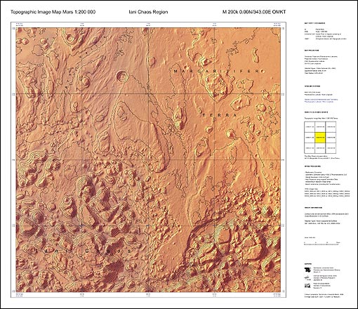
From BBC news
The "hiker's maps" provide detailed height contours and names of geological features on the Martian surface.
The European Space Agency (Esa), which compiled the maps, said it hoped the maps would become a standard reference for future research on the Red Planet.
The data, from the Mars Express spacecraft, has also been turned into 3-D models of the surface of Mars.
The topographic maps use contour lines to show the heights of the landscape.
The contour lines are superimposed upon high-resolution images of Mars, taken by the High-Resolution Stereo Camera (HRSC) aboard Mars Express.
The maps are much like those of Earth used by hikers and planning authorities.
The samples released by Esa show the Iani Chaos region of Mars because of its major topographical interest.
It is covered in individual blocks and hills that form a chaotic pattern across the landscape.
Mars Express entered orbit around the Red Planet in December 2003.
파일 역사
날짜/시간 링크를 클릭하면 해당 시간의 파일을 볼 수 있습니다.
| 날짜/시간 | 섬네일 | 크기 | 사용자 | 설명 | |
|---|---|---|---|---|---|
| 현재 | 2007년 2월 13일 (화) 12:40 | | 510 × 440 (75 KB) | Parha (토론 | 기여) | From [http://news.bbc.co.uk/2/hi/science/nature/6354991.stm BBC news] The "hiker's maps" provide detailed height contours and names of geological features on the Martian surface. The European Space Agency (Esa), which compiled the maps, said it hoped th |
이 파일을 덮어쓸 수 없습니다.
이 파일을 사용하는 문서
다음 문서 1개가 이 파일을 사용하고 있습니다: